 Golden Playbox
Prepared by Golden Playbox · Published November 13, 2026
How to play
- Print pages 1-3 for each player or pair. Keep pages 4-6 with the host.
- Circle one answer for each question. Read the choices aloud if helpful.
- Award one point per correct answer out of twelve, or play without scores.
About this printable round
A map can be a source of conversation even when no journey is planned. This printable quiz introduces twelve everyday geographical terms, from compass directions to symbols and coordinates. It does not require measuring a printed map or performing calculations. Three choices support each answer, and the separate key explains what the word means in practice. The round works as an approachable introduction before a capitals, rivers or landmarks game.
Host the conversation
Place an optional simple map on the table after the questions, not before, if the group wants a memory-based round. Then find its title, scale and key together. An alternative is to make the whole game a cooperative reference activity from the start. Ask participants to design a symbol for an imaginary picnic area and explain why it would be easy to recognize. Avoid assuming everyone can distinguish similar colors: symbols and labels are useful precisely because color is not the only way to convey information. This vocabulary game does not replace practical navigation training.
Questions, answers and talking points
The following walkthrough contains spoilers. Keep this section with the host if participants want to answer the printable questions first.
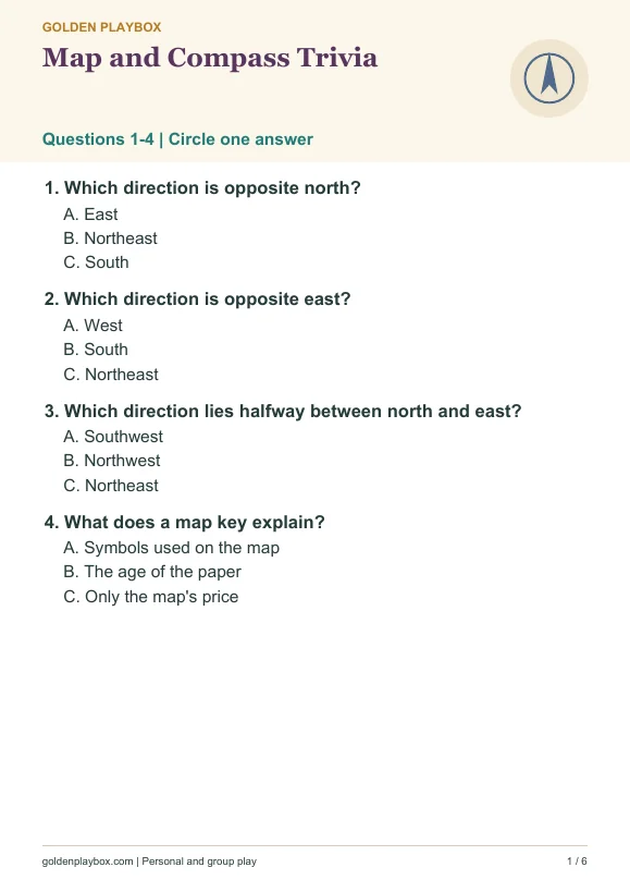
Which direction is opposite north? South. South is opposite north on a conventional compass rose. The relationship is more useful than memorizing a particular map's layout, which may be rotated.
Which direction is opposite east? West. West is opposite east. Together with north and south, these form the four cardinal directions commonly used to describe orientation and movement.
Which direction lies halfway between north and east? Northeast. Northeast lies between north and east. Intermediate compass directions combine neighboring cardinal names, providing a straightforward way to reason out the answer.
What does a map key explain? Symbols used on the map. A key or legend explains symbols. It helps readers interpret the information rather than assuming every map uses exactly the same marks or colors.
What does a map scale help relate? Map distance and real distance. A scale relates distances on the map to distances in the real world. Different map sizes can show the same area at different scales.
What imaginary line divides Earth into northern and southern hemispheres? Equator. The equator divides the northern and southern hemispheres. It is a line of latitude, distinguishing it from the prime meridian used for longitude.
What does latitude measure? Position north or south of the equator. Latitude describes angular position north or south of the equator. It is commonly paired with longitude to specify a location on Earth's surface.
What does longitude measure? Position east or west of a reference meridian. Longitude describes angular position east or west of a reference meridian. Together with latitude, it provides a coordinate rather than a complete street address.
Which reference line passes through Greenwich in traditional global mapping? Prime meridian. The Greenwich prime meridian is a familiar reference for longitude. Modern precise coordinate systems involve additional technical detail beyond the introductory level of this quiz.
What kind of map mainly shows national or regional boundaries? Political map. A political map emphasizes boundaries and places such as countries or cities. The word political describes its subject, not an endorsement of a political opinion.
What do contour lines on a map join? Points of equal elevation. Contour lines connect points at the same elevation. Their spacing helps communicate terrain shape, although practical interpretation requires more than this single definition.
What is a spherical model of Earth called? Globe. A globe represents Earth on a sphere. It avoids some distortions of flat maps, while flat maps remain useful for many kinds of detailed information.
Print and play
Choose A4 or US Letter, print at 100%, and keep any answers or calling list with the host. Free for personal and group activities. Printing help and hosting tips.
References for this game
More games to try
- The 1960s Quiz — Ten multiple-choice questions about familiar music, television and milestones of the 1960s.
- Working Life Cards — Working life includes paid jobs, unpaid responsibilities, informal help, and skills learned along the way.
- Neighborhood Stories Cards — Neighborhoods are made from ordinary details: a useful shop, a familiar corner, a place to pause, and the people who make a space welcoming.